Five of us ventured up to "Diamond Rock" fire lookout this afternoon. It was a 45 minute drive in a one-ton 4x4 crew cab on unimproved forest service roads from Shady Cove.
The distance from the forest service road to the base of the Diamond Rock pinnacles, is a short, but unbelievably steep, rugged (30-45 degrees) .25 mile, westerly hike, up decomposed granite. The former USFS Diamond Rock lookout is located on one of two vertical pinnacles a couple of hundred feet vertically, straight up (about 75-80 degrees). The ladders and stairs were removed when the tower was decommissioned and torn down. So, you rock climb to the top. Once at the top of the lookout, you are rewarded with an spectacular 360 degree view in all directions. I marveled at the concrete pillars of the former tower and wondered how in the world they (CYA?) hauled the cement and water up there to mix and pour the footings (they must have been REAL animals!).
From the top of the lookout, we could not recognize any change in foliage that would give clues to the location of a plane crash. We made our way back down to the road and proceeded to work our way, cross country, down the 30 degree slope, spaced about 50 feet apart side to side. I expected open understory beneath the conifers, but the undergrowth was fairly thick (I have the scratches to prove it). Wreckage could have been 20 feet away from you and you could have walked right passed it. We dropped onto FS 3102-340 (which was not on the map) and hiked back up to the main (if you could call it that) road.
It all, we were gone about 5 hours and did not see diddly squat (unless you include a couple million conifers, a couple of deer, and a grouse or two). I intend to revisit the area and try again. We only covered about a quarter of the area that I wanted to explore. There is still more area to explore. Next time, I will wear a heavy canvas long sleeve shirt.

This picture is very misleading. This pinnacle is about 25 feet wide and goes vertically straight down a couple hundred feet on the east side and about 500 feet on the west side.

West side of "Diamond Rock" pinnacles, as seen from the approximate location of the PBY crash
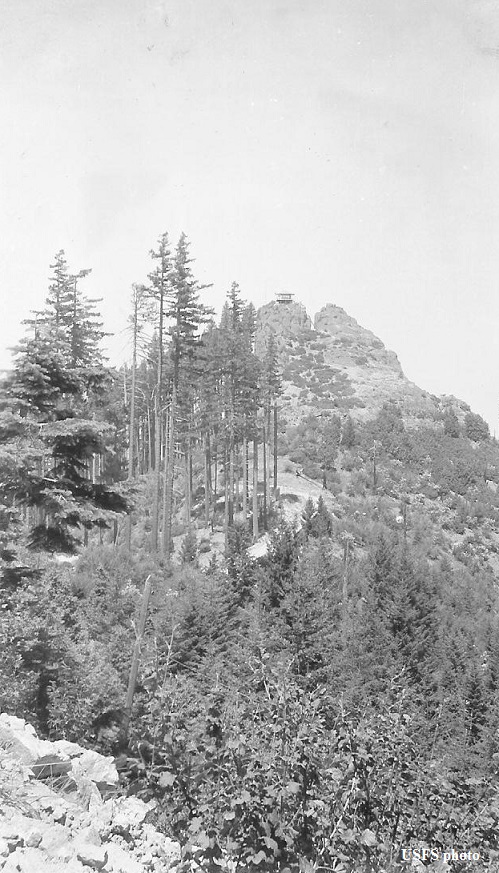
Circa 1941, looking west

Circa 1941