Hey everyone,
It's been a long time, but I finally heard back from some people about the A-20 in question.
My letter was passed around to several people in the local community, then to the Air Force, then to someone else and someone else again. Then the lines went silent as the person I needed to get in touch with was busy or away for an extended period of time. Then about 6 months later I get an e-mail filling me in on just about everything to do with the project.
Here's the info I've got for you all:
A-20(F-3) Havoc 39-741
It crashed 122 km southwest of Goose Bay, Labrador, on
October 10, 1942
The UAS (Underwater Admiralty Sciences - and the same people that recovered the B-17 from Labrador) group gained all proper permissions to recovery the airframe and began dismantling it and removing sections with the help of the Canadian Armed Forces last summer and it sounds like they intend to recover the rest of her before the end of the summer of 2009.
As for what the intentions are with it and where it's going to end up... I don't really know. It mentions an 8-10 year restoration and maybe I missed it but I couldn't figure out wheter it was going to be displayed. That being said, a company in Seattle, WA has been contracted to do the restoration.
I've attached a little info sheet that Mark Allen sent me. This is all pretty exciting stuff, I'd say.
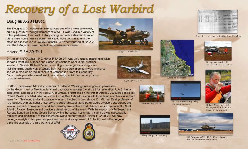
I've got some PDF's that Mark Allen sent me as well. I can forward them to whoever would like them. Just PM me and I'll e-mail them to you. They've got a little bit more in depth info on the recovery, and pictures of course.
Cheers,
David