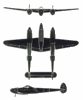
The emblen reads:
"Servicio Geodesico Interamericano." This means, Inter-American Geodesical Service / Survey.
During the 1950s and 1960s, the U.S. through the Corps of Engineers and the U.S. Army and Air Force (IIRC) provided aerial mapping services to several nations in South America, to cover the gaps in maps that existed of the region.
Now, this is pure speculation, and by the use of the logo on this photo Lighting, is there the possibility that the airplane was contracted for mapping work by the U.S.? It would seem to be so.
When I was learning to fly back in the early 80s, there were aerial charts of Central America for example, where areas over Nicaragua, showed the legend "relief data incomplete" still showing.
From my childhood in Guatemala, I recall seeing De Havilland Beaver (U.S. Army) in high visibility markings of white and bright orange, with the same Servicio Geodesico Interamericano emblem.
I have in my collection, a photo of a Hiller helicopter (Raven?) underslung a Guatemalan AF's UH-1H, and on the Hiller's boom, the Servicio Geodesico's titles also appear.
I would like to respectfully ask for permission to copy and post these photos in our web page (www.laahs.com) and see if we come up with more answers.
Could you please, provide:
1. Your permission for me to copy and post the photos?
2. The name of the photographer, and the location and date, if available?
Thank you!
Tulio