Weird Google Images
Tue Sep 16, 2008 11:29 pm
I was playing around with Google maps and ran across a plane that didn't seem to match the shadow at all. It must be some of quirky photo effect because I found some more planes that weren't even all there. Honolulu Intl airport. You might have to pan up slightly on the first link. It looks like a partial C-17 shadow with a KC-10 sitting on it with its shadow in a different place. On closer examination part of the C-17's left wing still seems to be there.
http://maps.google.com/?ie=UTF8&ll=21.329925,-157.93948&spn=0.002923,0.004141&t=h&z=18
http://maps.google.com/?ie=UTF8&ll=21.328761,-157.916037&spn=0.002923,0.004141&t=h&z=18
http://maps.google.com/?ie=UTF8&ll=21.329925,-157.93948&spn=0.002923,0.004141&t=h&z=18
http://maps.google.com/?ie=UTF8&ll=21.328761,-157.916037&spn=0.002923,0.004141&t=h&z=18
Tue Sep 16, 2008 11:51 pm
That is the new stealth C-7-10. It is an aircraft with a split personality... the other a/c are also stealth a/c- the nose must be visible on the ground so they know where to put airstairs or swing the ramp. They had a lot of problems before they decided to do that...
Alternately, this is the "Honolulu Effect" a problem caused by the Honolulu site for the "Pacific Philadelphia Experiment". Ever hear of the USS Eldridge?
Actually, looks like their overlapping satellite passes occurred just long enough apart the C-17 blocked out & my KC-10A blocked in, as well as the others...
Neat catch!
Robbie
Wed Sep 17, 2008 1:45 am
Those images are photomosaics..composites made up of several overlapping images stitched together (often taken at different times.) The probably use a fethered edge to make it less obvious, resulting in the "ghosting" effect.
SN
SN
Wed Sep 17, 2008 4:47 pm
Google updated this a while ago, but the picture of my old neighborhood in Edmonton used to have snow on the west side of 97th Street, and green grass and trees on the east side.
Wed Sep 17, 2008 6:35 pm
Wed Sep 17, 2008 7:35 pm
With so many images to compile, I imagine they've got some sort of software to automate the process. I tried looking up my hometown, but it's in a rural area with nothing but low res images.
SN
SN
Wed Sep 17, 2008 8:48 pm
I thought they just took a photo.
You can learn about everything here at WIX.
Steve
You can learn about everything here at WIX.
Steve
Tue Oct 07, 2008 8:59 pm
I was playing around with Google maps again and ws looking at the Beechcraft Company airport in Wichita, Kansas. What's the long winged plane?
http://maps.google.com/?ie=UTF8&ll=37.692196,-97.219509&spn=0.002483,0.004141&t=h&z=18
http://maps.google.com/?ie=UTF8&ll=37.692196,-97.219509&spn=0.002483,0.004141&t=h&z=18
Tue Oct 07, 2008 10:36 pm
Strange. Too small to be a U-2. Some sort of drone prototype, perhaps?
SN
SN
Wed Oct 08, 2008 12:10 am
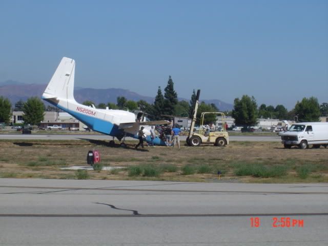
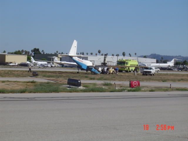
Possibly an Egret, one of them had the nose gear collapse on landing at Van Nuys a couple of weeks back.
Wed Oct 08, 2008 12:50 am
One placeI would love to be able to go and get ONE of my choicem SIGHHHH
http://maps.google.com/maps?f=q&hl=en&q ... 4&t=h&z=17
http://maps.google.com/maps?f=q&hl=en&q ... 4&t=h&z=17
Wed Oct 08, 2008 6:27 am
Looks like the Egret is most likely what it is. thanks much!
Wed Oct 08, 2008 12:32 pm
Egret huh? A MUSKETEER replacement with a 7600 mile range?
Oh my achin' tookus!
Oh my achin' tookus!