Re: Army Air Forces Aeronautical and Cloth Charts
Mon Jul 18, 2022 6:08 pm
I know someone who makes women's scarfs and she's always looking for new ideas. I sent her some photos of a few of these charts and I swear I could hear the gears engage from across the country when she got that email.
I asked only that if she made any, she'd make a few as exact reproductions of the originals. Nothing yet, though...
I asked only that if she made any, she'd make a few as exact reproductions of the originals. Nothing yet, though...
Re: Army Air Forces Aeronautical and Cloth Charts
Thu Nov 10, 2022 8:17 pm
The Smithsonian's Time and Navigation online exhibit has a collection of assorted maps. While not all of them are related to aviation and they are a limited selection, they are still valuable for offering a cross section of the different types of charts used during the war. Unfortunately, the resolution of the scans are rather low - although they are still zoomable:
Pilots Reference Strips
Plotting Series Sheets
Radar Plotting Charts
Special Air Navigation Charts (Cont.)
Special Air Navigation Maps
Target Charts
Target Maps and Approach Charts (Cont.)
Also, if you missed them, a pair of Link trainer chart scans and a list of a bunch more were posted in the Link Trainer thread:
Automatic Radio Range Charts
Instrument Trainer Charts
G-2 Dead Reckoning Navigation Trainer Recorder Sheets
Link Trainer Charts
VOR/ADF Link Charts
Pilots Reference Strips
Plotting Series Sheets
Radar Plotting Charts
Special Air Navigation Charts (Cont.)
Special Air Navigation Maps
Target Charts
Target Maps and Approach Charts (Cont.)
Also, if you missed them, a pair of Link trainer chart scans and a list of a bunch more were posted in the Link Trainer thread:
Automatic Radio Range Charts
- Blytheville, Ark.
- George Field, Ill.
- Jackson, Miss.
- Laughlin Field, Texas
- Moody Field, Ga.
- Pendleton, Ore.
- Waco, Texas
Instrument Trainer Charts
- Accra, Gold Coast
- Altus, Okla.
- Atkinson
- Beam, Bracketing
- Belem
- Ascension Island
- Boise, Ida.
- Brownsville, Texas
- Bryan, Texas
- Carlsbad, N. M.
- Casablanca, Morocco
- Casper, Wyo.
- Chanute Field, Ill.
- Charleston, S. C.
- Charlotte, N. C.
- Chattanooga, Tenn.
- Columbus, Miss.
- Dallas-Ft. Worth
- Dakar, Fr. W. Africa
- Deming, N. M.
- Denver, Colo.
- Frederick, Okla.
- Fresno, Calif.
- Goodfellow Field, Texas
- Harrisburg, Pa.
- Houston, Texas
- Indianapolis, Ind.
- Kano, Nigeria
- Las Vegas, N. M.
- La Junta, Colo.
- Little Rock, Ark.
- Long Beach, Calif.
- Louisville, Ky.
- Maidugur, Nigeria
- Marshall, Liberia
- Memphis, Tenn.
- Miami, Fla.
- Minneapolis, Minn.
- Moore Field, Texas
- Morrison Field, Fla.
- Nashville, Tenn.
- Natal, Brazil
- New Castle, Dela.
- Oran, Algeria
- Patterson Field, Ohio
- Philadelphia, Pa.
- Phoenix, Ariz.
- Pittsburg, Pa.
- Pocatello, Ida.
- Presque Isle, Me.
- St. Joseph, Mo.
- Scott Field, Ill.
- Shreveport, La.
- Sioux City, Ia.
- Stewart Field, N. Y.
- Tampa, Fla.
- Topeka, Kans.
- Tucumcari, N. M.
- Watertown, S. D.
- Wendover, Utah
- Chicago Area
- Great Falls Area
- Los Angeles Area
- New York Area
- Oakland Area
- Seattle Area
- San Antonio, Texas
- Terre Haute Area
- Instrument Landing-Standard Beam
- Approach and Controlled Descent through Clouds
- Instrument Landing-and Runway Localizer
- Radio Compass (QDM)
G-2 Dead Reckoning Navigation Trainer Recorder Sheets
- 28°N to 32°N
- 32°N to 36°N
- 36°N to 40°N
- 40°N to 44°N
- 44°N to 48°N
- 48°N to 52°N
Link Trainer Charts
VOR/ADF Link Charts
Re: Army Air Forces Aeronautical and Cloth Charts
Sun Nov 20, 2022 7:46 pm
The 416th Bomb Group website has a maps page that does a good job explaining the grid systems used by Allied bomber groups units in Europe for target identification. The links at the bottom lead to pages with good reference lists if you want to dig a bit deeper into how things worked. (Now, if only I could find an explanation of the numbering format for the Naval Air Combat Intelligence-Hydrographic Office target maps mentioned in a previous post.)
Also, a specialist at McMaster University, which is responsible for a large number of the digitized maps in this thread, has produced a PowerPoint presentation titled WWII on Land, Sea & Air Charts: The Demand and Challenge for Cartography (1942-1945). (An PDF version viewable without the need to be downloaded is also available from a different website.)
Next, although they're not available online, it's worth mentioning that the Library of Congress also has the Richard Houston Payne World War II map collection which includes "World War II-era maps and photo-maps of Japan by the U.S. Army Map Service and the U.S. Hydrographic Office".
Lastly, a few more digitized maps. Note that the cloth maps were mentioned in a previous post:
Cloth Maps (Cont.)
Target Maps and Approach Charts (Cont.)
EDIT (22-12-06): For a bit more on target maps, check out Air Forces Manual No. 41, Aids for Navigators and Bombardiers.
EDIT (22-12-08): The Bombardiers' Information File discusses "Target Folders" starting on page 8-3-1. The folder would include:
Examples of most of the charts are given on the immediately following pages. However, an additional instance of a target chart appears on page 8-10-6.
Also included on page 2-2-1 of the BIF is a Bombing Table, which is reproduced in inverted color (i.e. black background, white text). As a result, it is not only similar in content, but also looks much the same as the Bomb Loading Charts mentioned in a recent post in the Army Air Forces and Other World War II Forms thread.
Also, a specialist at McMaster University, which is responsible for a large number of the digitized maps in this thread, has produced a PowerPoint presentation titled WWII on Land, Sea & Air Charts: The Demand and Challenge for Cartography (1942-1945). (An PDF version viewable without the need to be downloaded is also available from a different website.)
Next, although they're not available online, it's worth mentioning that the Library of Congress also has the Richard Houston Payne World War II map collection which includes "World War II-era maps and photo-maps of Japan by the U.S. Army Map Service and the U.S. Hydrographic Office".
Lastly, a few more digitized maps. Note that the cloth maps were mentioned in a previous post:
Cloth Maps (Cont.)
Target Maps and Approach Charts (Cont.)
EDIT (22-12-06): For a bit more on target maps, check out Air Forces Manual No. 41, Aids for Navigators and Bombardiers.
EDIT (22-12-08): The Bombardiers' Information File discusses "Target Folders" starting on page 8-3-1. The folder would include:
Bombardiers' Information File wrote:Aeronautical chart of target area
Target charts and perspectives
Vertical and oblique photographs of target area
Terrain prints, sketches, or any other auxiliary material pertinent to mission
Examples of most of the charts are given on the immediately following pages. However, an additional instance of a target chart appears on page 8-10-6.
Also included on page 2-2-1 of the BIF is a Bombing Table, which is reproduced in inverted color (i.e. black background, white text). As a result, it is not only similar in content, but also looks much the same as the Bomb Loading Charts mentioned in a recent post in the Army Air Forces and Other World War II Forms thread.
Re: Army Air Forces Aeronautical and Cloth Charts
Fri Sep 08, 2023 5:46 pm
Long Range Air Navigation Charts (Cont.)
Special Air Navigation Charts (Cont.)
- N/A - Brazil
- N/A - Hawaiian Islands (First Edition, Second Edition)
Special Air Navigation Charts (Cont.)
- N/A - Azores-Marrakech-United Kingdom[1]
Re: Army Air Forces Aeronautical and Cloth Charts
Sun Mar 03, 2024 9:32 pm
For comprehension and comparison's sake, I thought it would be worthwhile to compare American civilian aeronautical charts during three different time periods: World War II, the 1970s and the present.
World War II
The second edition of Practical Air Navigation, published in 1945, lists nine types of aeronautical charts:
Name - Scale
This is an increase from the six offered pre-war, according to the 1939 edition of the publication. The local, airport and outline were the new charts. (However, a series of double-sided sheets called Airway Bulletins published from 1928 to 1931 did profile individual airports. So did the USAAF's Airport Directory of the Continental United States (Volume 1, 2, 3). These appear to be what eventually evolved into the modern airport diagrams mentioned later. Similarly, the strip maps may have evolved into enroute charts.) It also specifically notes that there are "a series of 43 planning charts covering the entire world has been prepared for the use of the Air Forces" that are not yet available to the public. This refers to the
1970s
A mail order catalog from 1973 listing the following charts as available to purchase:
Present
Today, according to the Aeronautical Chart Users' Guide, the FAA has divided charts into three major categories:
Each category contains several types of maps:
To end, a list of links to index maps:
A few other non-index, but still relevant, maps:
As a final note, as pointed out by an article on the subject on the website Beautiful Public Data, existence of alternatives such as Jeppesen we are quite lucky that the government provides such data free of charge to any and all aircrew. For all of the headaches that the bureaucracy and regulations at the FAA can cause, the production of such data is a vital public service that is often taken for granted.
World War II
The second edition of Practical Air Navigation, published in 1945, lists nine types of aeronautical charts:
Name - Scale
- Standard Charts
- Planning Charts - 1:5,000,000
- Radio Direction Finding Charts - 1:2,000,000
- Regional Charts - 1:1,000,000
- Sectional Charts - 1:500,000
- Local Charts - 1:250,000
- Airport Charts - 1:126,720
- Special Purpose Charts
- Magnetic/Isogonic Charts - 1:5,000,000
- Great Circle Chart - 1:5,000,000
- Outline Charts - 1:2,500,000
This is an increase from the six offered pre-war, according to the 1939 edition of the publication. The local, airport and outline were the new charts. (However, a series of double-sided sheets called Airway Bulletins published from 1928 to 1931 did profile individual airports. So did the USAAF's Airport Directory of the Continental United States (Volume 1, 2, 3). These appear to be what eventually evolved into the modern airport diagrams mentioned later. Similarly, the strip maps may have evolved into enroute charts.) It also specifically notes that there are "a series of 43 planning charts covering the entire world has been prepared for the use of the Air Forces" that are not yet available to the public. This refers to the
1970s
A mail order catalog from 1973 listing the following charts as available to purchase:
- Enroute High Altitude Charts
- Enroute Low Altitude Charts
- Area Navigation (RNAV) High Altitude Chart
- Planning Chart
- World Aeronautical Charts
- Alaska Aeronautical Charts
- Alaska Enroute Low Altitude Charts
- Alaska Enroute High Altitude Charts
- Operational Navigational Charts
- Enroute Pacific Ocean and Hawaii Islands Chart
- Aeronautical and Operational Navigation Charts
- Sectional and VFR Terminal Area Chart
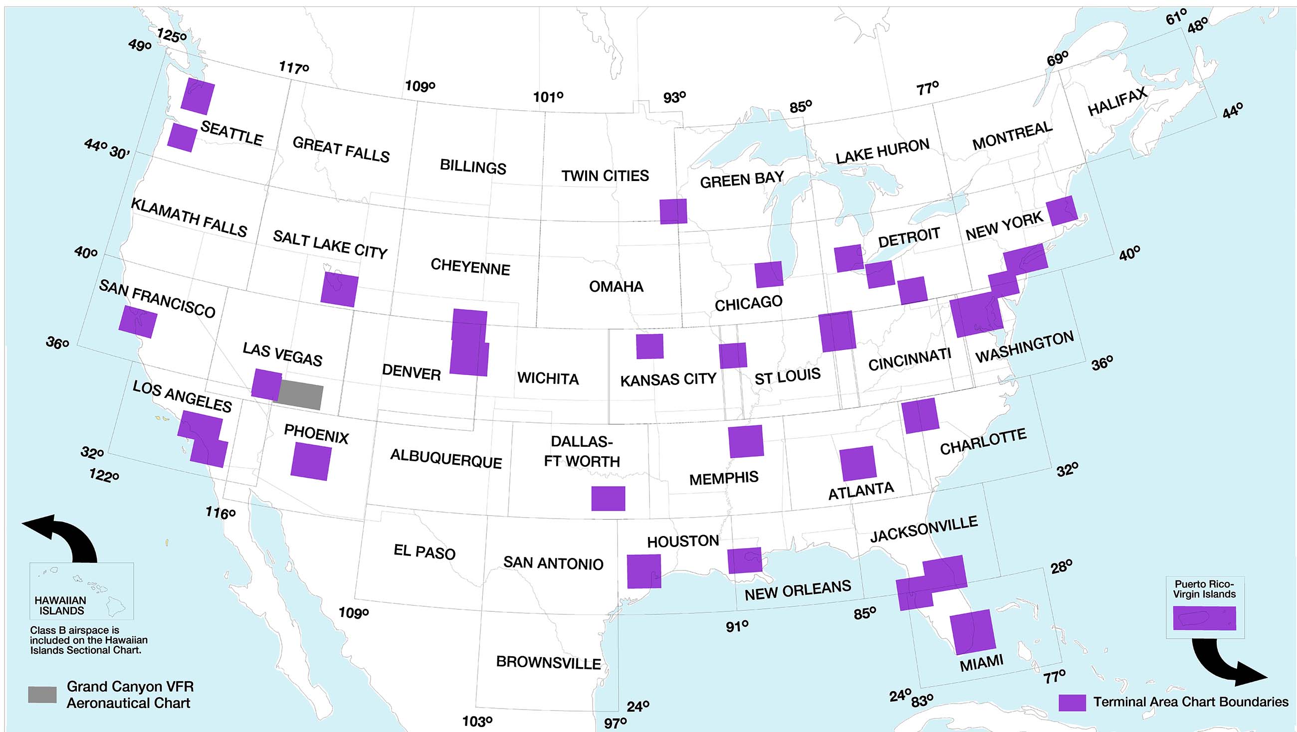
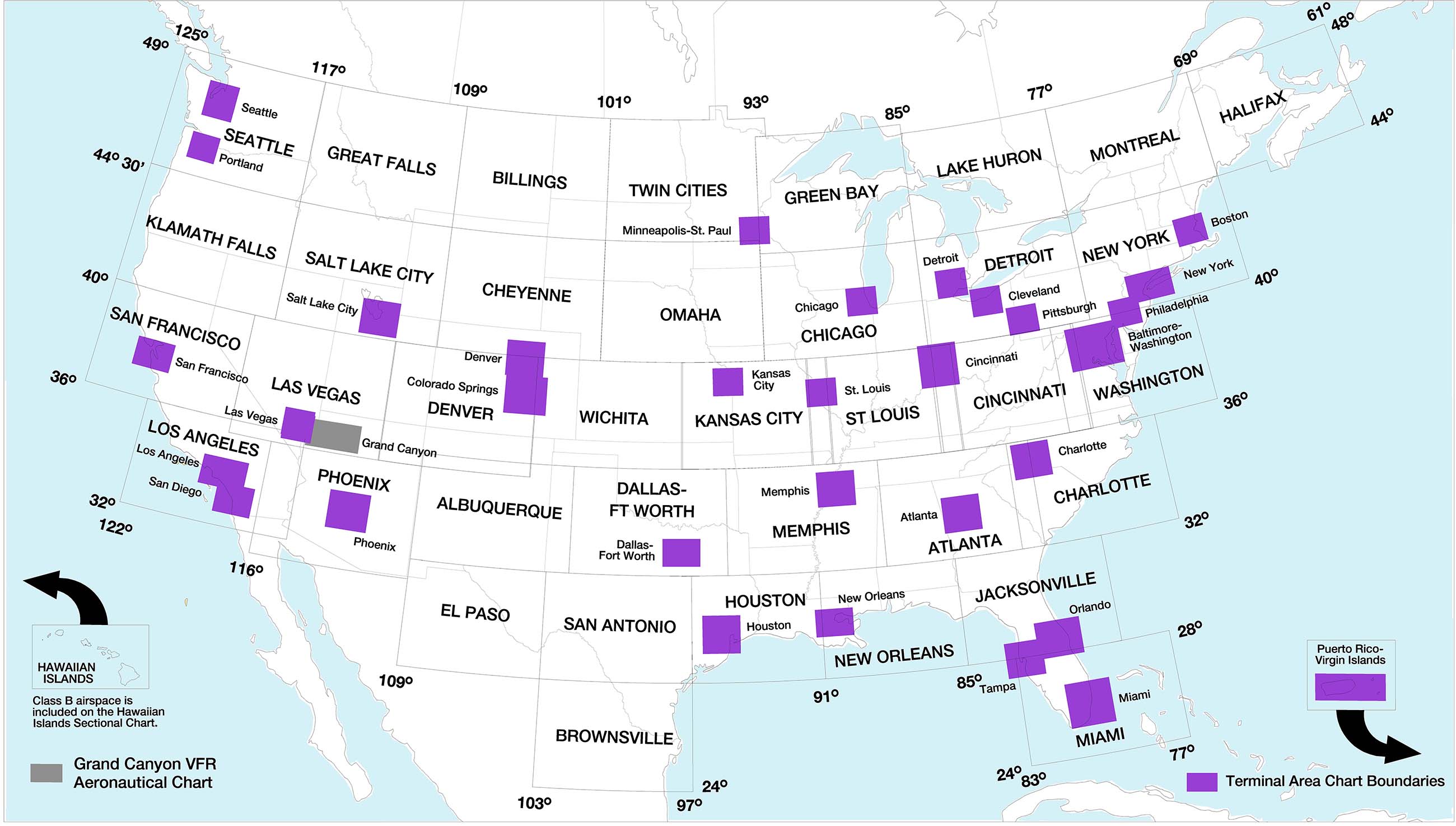
Present
Today, according to the Aeronautical Chart Users' Guide, the FAA has divided charts into three major categories:
Each category contains several types of maps:
- VFR Charts
- Sectional
- Terminal Area
- Helicopter
- Grand Canyon
- Caribbean
- Planning
- IFR Enroute Charts
- Enroute Low
- Enroute High
- Area
- Caribbean
- Gulf of Mexico
- Planning
- Terminal Procedures Publication
- Instrument Approach Procedure (IAP)
- Departure Procedure (DP)
- Standard Terminal Arrival (STAR)
- Charted Visual Flight Procedure (CVFP)
- Airport Diagrams (AD)
- Other
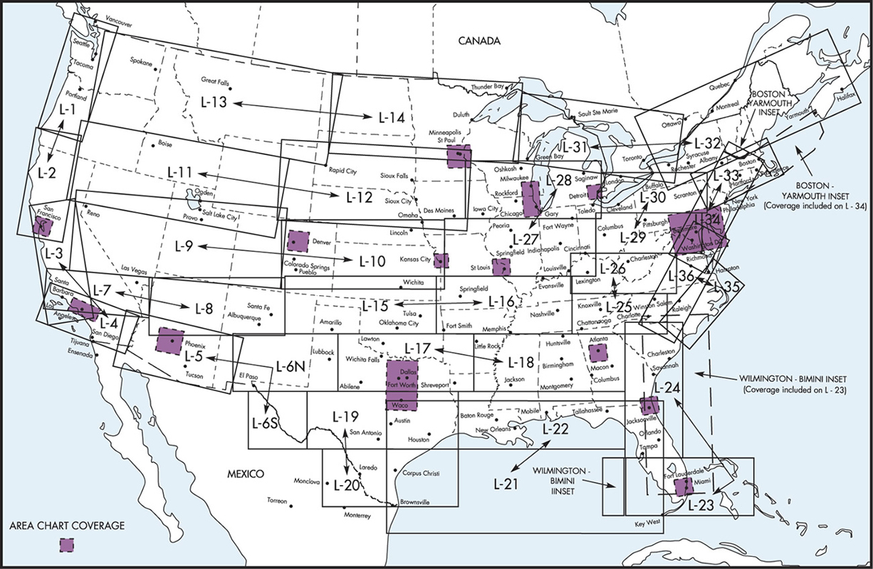
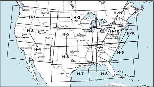
To end, a list of links to index maps:
- Sectional (1939)
- Regional (1939)
- Radio Direction Finding (1939)
- Sectional & Regional with Sectional Numbers (1943?)
- Sectional & Regional (1945)
- Alaska (1945)
- Regional & International (1945)
- Sectional (2024)
- Sectional, Alaska (2024)
- Terminal (2024)
- Terminal, Alaska (2024)
- Terminal, Caribbean (2024)
- Enroute, Low Altitude (2024)
- Enroute, High Altitude (2024)
- Enroute, Low Altitude, Alaska (2024)
- Enroute, High Altitude, Alaska (2024)
- Enroute, Hawaii/Pacific (2024)
- Enroute, Caribbean (2024)
- Gulf of Mexico (2024)
A few other non-index, but still relevant, maps:
As a final note, as pointed out by an article on the subject on the website Beautiful Public Data, existence of alternatives such as Jeppesen we are quite lucky that the government provides such data free of charge to any and all aircrew. For all of the headaches that the bureaucracy and regulations at the FAA can cause, the production of such data is a vital public service that is often taken for granted.
Last edited by Noha307 on Sun Mar 03, 2024 9:50 pm, edited 1 time in total.
Re: Army Air Forces Aeronautical and Cloth Charts
Sun Mar 03, 2024 9:36 pm
As a follow up to the above, attached are a series of scans from the 1973 publication:
(Source: All Aircraft Parts & Pilots Supplies (Van Nuys, California, 1973), 20-22.)
(Source: All Aircraft Parts & Pilots Supplies (Van Nuys, California, 1973), 20-22.)
Last edited by Noha307 on Sun Mar 03, 2024 9:42 pm, edited 1 time in total.
Re: Army Air Forces Aeronautical and Cloth Charts
Sun Mar 03, 2024 9:38 pm
Part 2:
(Source: All Aircraft Parts & Pilots Supplies (Van Nuys, California, 1973), 22-24.)
(Source: All Aircraft Parts & Pilots Supplies (Van Nuys, California, 1973), 22-24.)
Re: Army Air Forces Aeronautical and Cloth Charts
Sun Mar 03, 2024 9:46 pm
Part 3:
(Source: All Aircraft Parts & Pilots Supplies (Van Nuys, California, 1973), 19.)
(Source: All Aircraft Parts & Pilots Supplies (Van Nuys, California, 1973), 19.)
Re: Army Air Forces Aeronautical and Cloth Charts
Thu Mar 14, 2024 5:31 pm
So, there's a series of technical orders that were issued during the war that deal with flying in the United States. They are:
The -1 includes, as it says on the cover, charts showing radio ranges throughout the United States. The -2 only has a few charts and is instead mostly radio stations by frequency, graphs of daylight/darkness, fuel/oil availability by airport, various procedures and, finally, a bunch of copies of Damage to Property Certificates, AAF Form No. 17, in case you damage a farmer's fence during your emergency landing. The -3 is entirely made up of something resembling modern day approach plates, except they show low-frequency radio range quadrants.
It is worth comparing with the U.S. Army Air Force Airport Directory [of] the Continental United States mentioned in a previous post as, although the latter was confidential, and therefore likely not handed out to pilots, they are all military produced sources of information about airports in the United States. (For foreign airports, you would have to consult wherever the information collected by Foreign Airport Description, AAF Form No. 63, which is mentioned in a post in another thread, was sent.)
Furthermore, given the context in which the T.O. 08-15 series was encountered, it seems that they would have frequently accompanied the instrument flying manuals mentioned in a post in another thread.
- T.O. No. 08-15-1 - Army Air Forces Radio Facility Charts
- T.O. No. 08-15-2 - Army Air Forces Radio Data and Flight Information
- T.O. No. 08-15-3 - Army Air Forces Instrument Letdown Procedures
The -1 includes, as it says on the cover, charts showing radio ranges throughout the United States. The -2 only has a few charts and is instead mostly radio stations by frequency, graphs of daylight/darkness, fuel/oil availability by airport, various procedures and, finally, a bunch of copies of Damage to Property Certificates, AAF Form No. 17, in case you damage a farmer's fence during your emergency landing. The -3 is entirely made up of something resembling modern day approach plates, except they show low-frequency radio range quadrants.
It is worth comparing with the U.S. Army Air Force Airport Directory [of] the Continental United States mentioned in a previous post as, although the latter was confidential, and therefore likely not handed out to pilots, they are all military produced sources of information about airports in the United States. (For foreign airports, you would have to consult wherever the information collected by Foreign Airport Description, AAF Form No. 63, which is mentioned in a post in another thread, was sent.)
Furthermore, given the context in which the T.O. 08-15 series was encountered, it seems that they would have frequently accompanied the instrument flying manuals mentioned in a post in another thread.
Re: Army Air Forces Aeronautical and Cloth Charts
Thu Mar 21, 2024 4:40 pm
p51 wrote:I know someone who makes women's scarfs and she's always looking for new ideas. I sent her some photos of a few of these charts and I swear I could hear the gears engage from across the country when she got that email.
She's not the only one. The Spring 2024 issue of Air and Space Quarterly features a story about a woman named Bernice Maxwell who turned some of her husband's escape maps into a blouse.