Here is an excerpt I found about the crash:
A Fatal PBY-5A Crash The Executive Officer at CGAS Port Angeles was Lieutenant Commander James MacIntosh. (He was senior, of course, to me.) He only flew to get the
required four hours a month to receive flight pay. He
avoided instrument training flights altogether. I needled him about it and he said he would like to fly more but
his job as Exec kept him at his desk. When orders to
ferry a PBY-5A Catalina from Port Angeles to Elizabeth City, N.C., for overhaul came through,
he accepted the opportunity to not only get in a lot of flight hours but a lot of simulated instrument flight time.
The Fatal Flight.
MacIntosh
selected one of our
most skilled pilots whose name I cannot remember. He had come up through the ranks to Lieutenant. He
loved instrument flight, but he also
took chances, especially on rescue missions. They would have an Aviation Machinist and a Radioman as crew. They were scheduled for a Saturday morning takeoff to land for the night in Medford, Oregon, south of Portland.
I (the Operations Officer) was called at home in the late afternoon with the report the plane had not yet reported its arrival. I went immediately to the station and we began checking with air traffic control and all the airports en route.
I learned that the pilots had decided to
maximize instrument time by
“flying under the hood” when not flying in real instrument conditions. “Under the hood” means covering the cockpit windows with amber isinglass and having the pilot “on instruments” wearing a blue glass eye shield. The pilot can see the dashboard instruments through the blue film but cannot see outside as that view is blacked out by the combination of blue and amber. The copilot, however, can see everything in the cockpit and outside just as if wearing sunglasses. I had no knowledge of their plan.
Their flight plan began to unravel. They were flying on an instrument clearance (IFR) between Portland and Medford at ten thousand feet at the PBY’s cruising airspeed of about one hundred forty knots bucking a forty-knot headwind. It was very turbulent and must have felt like they were never going to get to Medford. They cancelled their instrument clearance and
dropped down to fly below the clouds at 6,000 feet using visual flight rules (VFR). Contact was lost.
The Search.
I spent a restless night at the station. I convinced the CO it was wishful thinking that they might have found an alternate airport and that I would take the ready PBY and search the route. He didn’t object.
The weather had moderated. The winds were still from the south. Most of the turbulence was caused by thermals. I held their altitude of 6,000 feet easily until just in the lee of the ridge when a downdraft hit us and we had to quickly turn and get out of there.
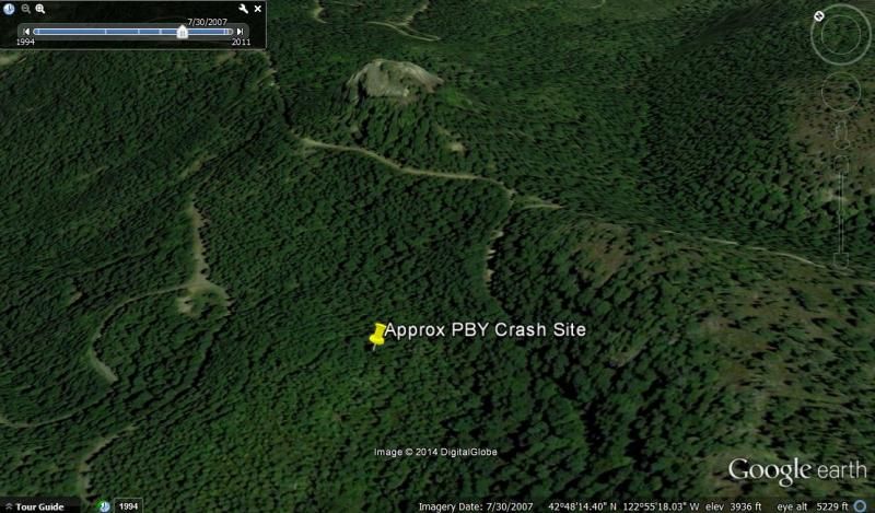
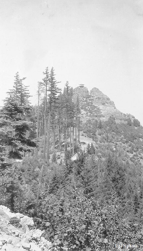
On our second pass, I stayed a little higher and we spotted smoke. We circled and identified it as the crash and, in that pass, we
spotted persons at a fire lookout station waving at us. We prepared and dropped them a message block telling them of the sighting west about four hundred yards.
I landed at Medford and joined the land party being organized to go to the wreck to remove the bodies. The crash was a terrible sight. The four man crew was incinerated at their stations. But there was amazing news—two seamen who were getting a ride survived the crash. Riding in the waist section of the plane, they were slammed against the bulkhead but not otherwise hurt. The older of the two reported that he immediately opened the door to go forward to see if he could help and was met by flames. The two jumped out the blisters and ran for their lives to a safe distance, where the rescue party found them.
The Investigation concluded that the pilots probably studied the
chart and found the
highest point on the ridge immediately north of Medford to be
5,050 feet.
At 6,000 feet, they would clear the ridge by nearly 1,000 feet. But at the ridge they entered clouds,
hit a downdraft losing at least 200 feet, and
crashed into the forest of evergreen trees. The
plane burst into flames about 200 feet below the crest. That doesn’t calculate. What went wrong?
Charts were checked. They had the latest issue. However, an older issue showed the ridge at 5,850 feet. The newer chart showed the eight crudely changed to zero! (Does that calculate? 6,000-foot flight altitude minus 200-foot downdraft equals 5,800 feet. But
the ridge crest is at 5,850 feet!!)
The sad fact remains that
they violated Visual Flight Rules by entering the clouds thinking they could
squeak over the ridge.
From:
https://www.uscg.mil/history/WEBORALHIS ... lair22.pdf